
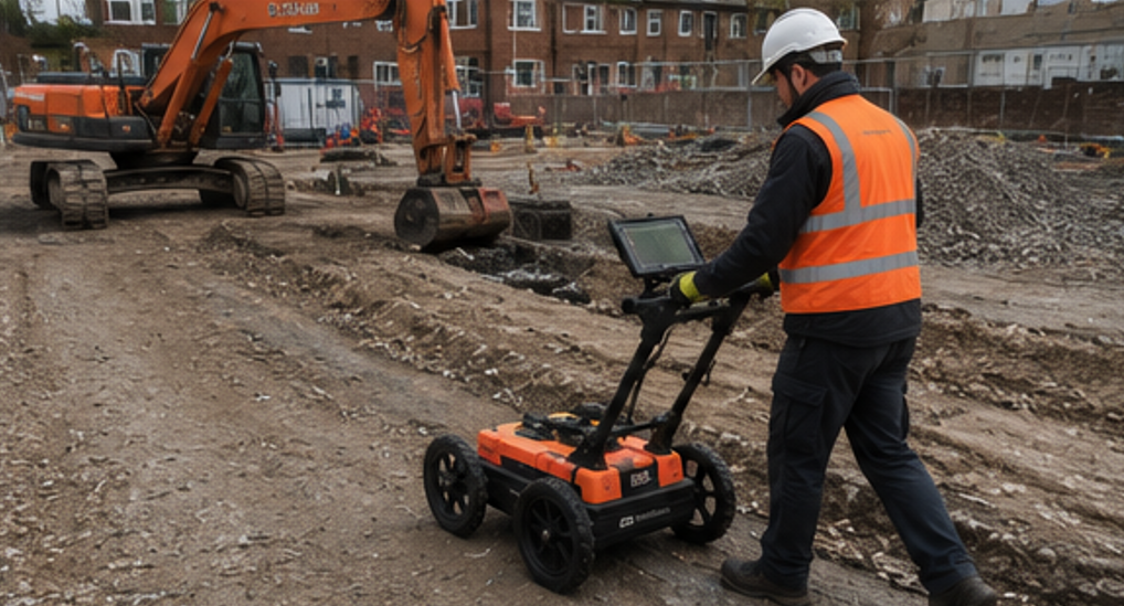
Surveys for Utilities, Drainage & Below-Ground Risk
Cura Surveys provides underground utility mapping and drainage survey services for developers, architects, engineers, contractors, property owners and project managers across the UK.
Before excavation, redevelopment or construction begins, project teams need reliable information about buried services, drainage routes and below-ground constraints. We provide PAS128 utility surveys, ground penetrating radar, electromagnetic tracing, drainage CCTV inspections and coordinated topographical survey drawings.
Our surveys help clients understand potential below-ground risks, plan works more safely and reduce reliance on incomplete or outdated records.
Understanding Below-Ground Site Constraints
Buried utilities and drainage systems may not be accurately shown on existing drawings or statutory records. Service routes may have changed, undocumented connections may exist, and some features may be difficult to detect from the surface.
Our surveys can help identify and map:
- Electricity cables
- Telecommunications routes
- Water mains
- Gas services
- Drainage pipes
- Foul and surface-water systems
- Ducts and service corridors
- Manholes and chambers
- Gullies and drainage covers
- Utility markers and inspection points
- Visible service connections
- Potential unidentified radar responses
Survey results are presented clearly for use by design, construction and site teams.
PAS128 Underground Utility Surveys
Cura Surveys provides PAS128 utility survey services using appropriate combinations of desktop records, visual inspection, electromagnetic locating and ground penetrating radar.
The survey can include:
- Review of available utility records
- Site reconnaissance
- Electromagnetic service tracing
- Ground penetrating radar scanning
- Survey of visible utility features
- Position and depth information where detectable
- Utility mapping in CAD format
- Coordination with topographical survey information
- PAS128 quality-level reporting where included in the agreed scope
The final drawing helps the project team understand the known and detectable utility environment before design or excavation works begin.
Ground Penetrating Radar and Electromagnetic Locating
No single method can detect every buried service. We therefore use complementary techniques where appropriate.
Ground penetrating radar can help identify buried features based on changes beneath the surface. Electromagnetic locating can trace conductive services or utilities carrying a detectable signal.
Using both methods can improve coverage across the site and help identify:
- Metallic and non-metallic services
- Ducts and service trenches
- Pipes and cables
- Changes in buried construction
- Unidentified radar responses
- Connections between visible surface features
Detection depends on site conditions, utility material, depth, ground type, congestion and access.
Drainage CCTV Surveys
Drainage CCTV surveys provide visual information about the condition and route of accessible drainage pipes.
Our drainage services can include:
- CCTV inspection of accessible pipework
- Manhole and chamber records
- Pipe diameter and material information
- Direction and connectivity
- Defect observations
- Blockages, displacement and damage
- Root intrusion or debris
- Still images and video records
- Drainage survey reports
- Invert levels relative to cover where included
- Jetting or descaling where separately agreed
CCTV information can support refurbishment, redevelopment, maintenance, drainage design and investigation of existing problems.
Coordinated Topographical, Utility and Drainage Surveys
Where a project requires a more complete understanding of the site, we can combine topographical, utility and drainage information into one coordinated survey package.
This can include:
- Existing ground levels
- Buildings and structures
- Roads, kerbs and footways
- Walls, fences and boundaries
- Drainage covers and chambers
- Visible utility features
- Detected underground services
- Drainage routes and connections
- Access areas and site constraints
- CAD drawings using a common grid and datum
Providing coordinated information reduces gaps between separate survey datasets and gives the design team a clearer picture of both above-ground and below-ground conditions.
Typical Projects
Our utility and drainage survey services support:
- Construction and excavation projects
- New developments
- Residential and commercial redevelopment
- Public-realm improvements
- Highways and access works
- Drainage alterations
- Building extensions
- Utility diversions
- Car parks and external works
- School and public-sector estates
- Industrial and infrastructure sites
- Refurbishment and change-of-use projects
- Pre-acquisition investigations
- Maintenance and asset-record updates
Survey Deliverables
Depending on the agreed scope, deliverables can include:
- PAS128 utility survey drawings
- CAD utility maps
- PDF survey drawings
- GPR survey results
- Electromagnetic tracing information
- Utility depth observations where detectable
- Topographical survey drawings
- Manhole and chamber schedules
- Drainage CCTV reports
- CCTV video and still images
- Pipe route and condition information
- Coordinated utility, drainage and surface-feature data
Survey Scope and Limitations
Utility and drainage surveys reduce uncertainty, but non-intrusive methods cannot guarantee that every buried feature will be detected.
Survey results may be affected by:
- Depth of the utility
- Service material
- Ground conditions
- Reinforced concrete
- Surface access
- Congested service areas
- Standing water or debris
- Inaccessible chambers
- Blocked drainage pipes
- Incomplete statutory information
The survey scope, methods and limitations are clearly stated so the project team understands how the information should be used.
Why Choose Cura Surveys?
Cura Surveys combines utility and drainage investigation with wider land, building and engineering survey capability.
We provide:
- RICS-regulated survey services
- More than 20 years of surveying experience
- PAS128 utility survey capability
- Ground penetrating radar and electromagnetic tracing
- Drainage CCTV inspections and reporting
- Topographical, engineering and measured building surveys
- Coordinated CAD survey deliverables
- Total station, GNSS and laser scanning capability
- Clear survey scopes and stated limitations
- Practical information for design, construction and risk management
Our focus is to provide clear and usable information that helps project teams better understand below-ground risks before work begins.
Relevant Project Experience
Our experience includes survey support for major buildings, regeneration schemes, listed properties, retail fit-out projects, public venues and complex sites.
- London County Hall — Full Measured Survey & Lift Shaft Verticality Survey
- OVO Arena Wembley — Full Measured Building Survey & 3D Laser Scanning
- Sutton High Street Regeneration — Multi-Site Survey Programme
- Borough Market — Full Survey, Area Measurement & Reconfiguration Support
- Gucci, New Bond Street — Full Measured Survey & Post-Strip Survey
- London Borough of Southwark — Revit BIM, Airspace, Infill & Topographical Survey
- Somerset House — 3D Scanning & Level Survey for Exhibition Works
- Imperial Riding School Hotel, Vienna — Full Measured Building Survey
- Grand Union Canal — Large Topographical Survey & 3D Laser Scanning
- Crofton and Sparrow Woods — Topographical, Hydrographic & Bathymetric Survey
- Ruthin School — Full Measured Building & Topographical Survey
- Grade II Listed Building, London — Detailed Measured Survey
- Retail & Hospitality Fit-Out Projects — Measured Survey Support
These projects show our ability to support architects and consultants working across different building types, scales and design stages.
Related Services
- Measured Building Surveys
- Topographical Surveys
- Area Referencing & IPMS Surveys
- 3D Laser Scanning Surveys
- Scan to BIM Services
- Revit Survey Models
- Drone Surveys
- PAS128 Utility Surveys
- Drainage CCTV Surveys
- Digital Twin Survey Data
For redevelopment projects, our measured building surveys, topographical surveys and Revit BIM models can be combined into one coordinated survey package.
Planning Work Around Utilities or Drainage?
Cura Surveys provides PAS128 utility surveys, GPR scanning, electromagnetic service tracing, drainage CCTV inspections and coordinated topographical survey data for construction, development and refurbishment projects across the UK.
Send us the site location, survey extent, available utility records, required deliverables and programme, and we will provide a clear fixed-fee quotation.

Posted on GoogleTrustindex verifies that the original source of the review is Google. We were particularly happy with how easy the whole process was to organise, from start to finish. Communication was clear and prompt throughout, and Lei was professional, friendly, and completely unobtrusive while carrying out the survey. The drawings are excellent and very clear, and we would happily recommend this company to anyone looking for this service.Posted on GoogleTrustindex verifies that the original source of the review is Google. Cura Surveys were wonderful. It took very little time to organise an appointment to measure my flat, and the measured survey came through on time. Additionally, Lei was kind enough to send me a PDF version with some specific measurements I needed which were otherwise very hard for me to calculate given that I don't have the software my architects/designers have.Posted on GoogleTrustindex verifies that the original source of the review is Google. Very efficient and professional.Posted on GoogleTrustindex verifies that the original source of the review is Google. Excellent service.Posted on GoogleTrustindex verifies that the original source of the review is Google. Cura Surveys offer & deliver a first class, attentive service. They are flexible and efficient. And the quality of the survey outputs are great. I thoroughly recommend Lei & the team.Posted on GoogleTrustindex verifies that the original source of the review is Google. Well donePosted on GoogleTrustindex verifies that the original source of the review is Google. We approached Lei for a building & topological survey in preparation for planing, such a lovely person and the plans were off a very high standard. I would strongly recommend this company, plans came back in a week, easy communication and very professional. My architect is very happy. They are also very reasonable with costs. Excellent all rounder. Thank you Lei. A very happy customer. ChantalPosted on GoogleTrustindex verifies that the original source of the review is Google. We are an Engineering company based in London and have worked with Lei on several occasions on various projects within the construction industry. The quality of scans are always excellent quality, and provide a very efficient service. We look forward to working with Cura surveys in the future.Posted on GoogleTrustindex verifies that the original source of the review is Google. We used Cura Surveys for two of the residential projects we have been involved with and we’re impressed with their level of professionalism. They were courteous on site and provided a complete and high quality survey. Wouldn’t hesitate to recommend.
Call us on 0203 488 5858 or email info@curasurveys.co.uk with your project details. We’ll provide a clear no-obligation quote (with no hidden costs) and feasible timescales.